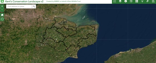
Kent’s Conservation Landscape Information Tool
Through landowner entries to the Landscape Information Tool, the State of Nature in Kent 2021 report presents a picture of land positively managed for wildlife in Kent and Medway and this is one of the baselines we need for nature recovery.
More of this data is needed however and the link to the tool is provided below.
There has always been a difficulty in accurately measuring land under conservation management at a county scale and although uptake on the tool was not as high as hoped, this is still a ground-breaking development, and the tool will be further developed.
The Kent’s Conservation Landscape Tool was developed by the Nature’s Sure Connected project to facilitate parcel-by-parcel recording of positive management action across a 3-tired rank of management quality (1. beneficial, 2. useful, 3. uncertain) i.e., practical management through to telephone advice. Prior to this it gathered only broad overlapping spatial information that did not allow for accurate area calculation.
Findings from the tool are presented in the Headlines section of the State of Nature in Kent report.